
If you are looking for Plymouth Place on an old map of Chicago, and cannot find it, here are some tips. These suggestions apply to old maps, probably from around 1895 to around 19o5. Much before that or after that, this might not be as helpful. Also, some street names may vary, depending on the map you are looking at. (Based on Google Maps, I think that today’s Plymouth Court is a much longer street.)
And even if you don’t want to consult any old maps, the following is relevant to the whole S.W. Erdnase story.
First, Plymouth Place is located very roughly half-way up the Chicago coastline — not exactly on the Lake Michigan coast, but quite near. On the typical map, you will see an extremely straight vertical section of coast, with a large breakwater in two sections, almost enclosing a section of Lake Michigan. Once you find that breakwater, you have almost found Plymouth Place. It is a north-south street. To the east of Plymouth Place, there are only three main streets running north-south between Plymouth Place and the coast. First there is State Street, then Wabash Avenue, then Michigan Avenue. Then — water!
To the west of Plymouth Place, north-south, is basically Dearborn Street. However, Dearborn Street seems to disappear in one or more places, such as near Dearborn Station, which seems right in its path. And speaking of Dearborn Station, Plymouth Place runs up the eastern side of Dearborn Station, which is located at Polk Street — and for a stretch in that area, the street immediately to the west of Plymouth Place is Custom House Place.
It appears that Plymouth Place (or, if there are other sections of the street anywhere, the relevant portion of it) starts at 12th Avenue, which is an east-west street that lines up pretty well with (or points roughly toward) the south tip of the breakwater. Then from there (that is, from 12th Avenue), Plymouth Place runs northward all the way to Jackson Street, where it seems to come to an abrupt end — while Dearborn, to the west, and State Street, to the east, keep running northward.
As a very rough approximation, I estimate that the Plymouth Place of 1902 (or the relevant segment of it) was approximately seven-tenths of a mile long — more than a half-mile, and less than a mile.
Here is a listing of cross-streets, starting at the north end of Plymouth Place and going to the south end of Plymouth Place:
Jackson Street
Van Buren Street
Harrison Street
Polk Street
Taylor Street
12th Street
The above discussion is based primarily upon two maps on the University of Chicago website. The first one (probably the clearer of the two) shows Chicago “between 1897 and 1899.” The second one shows Chicago, “1892, northeast corner.” (It is actually one-fourth of a larger map.)
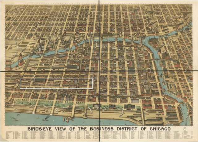
(Note of August 9, 2023: I’m not certain that Plymouth Place went as far south as 12th Avenue. When I originally posted this post, I included links to the two maps mentioned. But those links stopped working. Here is a link to a map that is one of the best for Erdnase purposes: Link. Below is a small image of the map, with the main area of interest enclosed within a white box, just to help you find Plymouth Place after you click on the link to the map.)
—Tom Sawyer
August 9, 2023
