
Back in April, I mentioned on the Erdnase thread of the Genii Forum that I was working on a reprint of S.W. Erdnase: Another View. I’m now almost at the end of my work on getting that out and for sale. At the moment, I am awaiting proof copies from Amazon. As seems to be the norm with me, the project was far more time-consuming than I had expected, and I’m glad to be basically done with the writing for this edition. It turned out to be much more that a reprint, since I added a few chapters, and a new preface, and also I put together a lot of annotations.
[NOTE (August 1, 2023): As I explained in detail in another post, I received the proof copies, and they look fabulous, but for various reasons that project is essentially on hold. I haven’t looked at those proofs since the day they arrived, and I don’t know when I will continue to review them (if ever, LOL). That revised version might not appear at all, and if it does, it will likely be 2024 or later.]
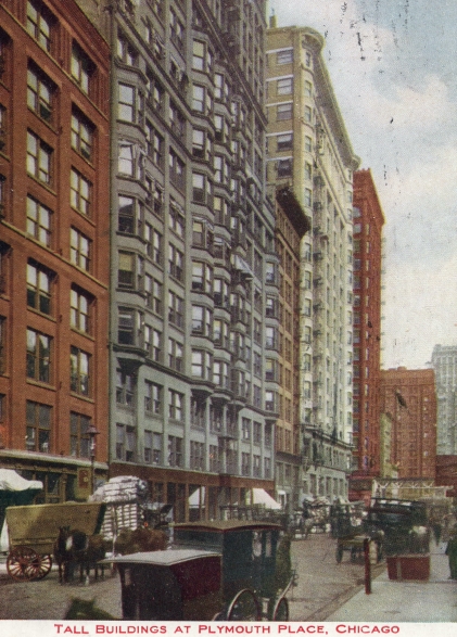
Anyway, as part of the wrap-up, I figured that the book needed a frontispiece, and I decided (provisionally, at least) to use a version of the following image of buildings on Plymouth Place. (If I use it, it will be in black and white in the book.) This is of interest, because James McKinney & Co. had its business location on Plymouth Place.
The image below is from a post card. I have cropped it. I’m not certain when this image dates from. There are several versions that can be seen on the internet, including a few on eBay. Based on a quick survey by me, it appears that most of the post cards where this basic image is seen have not been mailed and hence have no cancellation date. The earliest date I saw on any of the internet images was on a post card that was hand-dated in 1905. The example I have was hand-dated in 1908.
I made an effort to determine precisely what part of Plymouth Place is depicted in the image. After an arduous investigation, I arrived at a provisional guess.
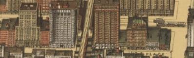
From what I gather, Plymouth Place ran from Taylor Street* northward through Polk Street, then through Harrison Street, then through Van Buren Street (where the elevated train passed over it), and up to Jackson Boulevard, where Plymouth Place stopped. So, it was a rather short street (unless it continued somewhere after an interruption). (These statements are based on an 1898 map on a Library of Congress website.) Here is a section of that map, which I have marked up:
![]()
North is basically to the right on this map.
The green box at the left shows Taylor Street, which runs east and west (down and up).
The red arrow basically shows Plymouth Place, which on the map is almost completely obscured by buildings to the east (bottom of the map). The arrow starts after the “H” in PLYMOUTH, and the arrow’s point stops just before the word PLACE.
The yellow box is at Van Buren Street, and you can see the train route that passes over Plymouth Place.
The blue box shows Jackson Boulevard, marking the north end of Plymouth Place.
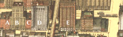
The following image from the same map shows (in larger size) the buildings on the west side of Plymouth Place, starting at the left from a point somewhat north of Harrison Street. You can see the elevated train’s route running vertically near the center of the image.
Here is the post-card image again, with some of the buildings labeled A through E. It is highly unlikely that the original photograph was in color, but it is possible that the colors shown were used by the colorist to approximate the actual colors. (I know for a verifiable fact that the colors in postcards of the era could differ wildly from the real colors, however.) I tend to assume that the colors on the map are indeed reasonably accurate. Anyway:
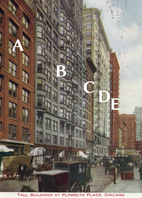
I think those last two buildings (unlabeled, at the far right of the image) are likely either (a) not on Plymouth Place (especially the one on the far right), or (b) at least are very near the north end of Plymouth Place.
Here is an image from the map again, with certain buildings labeled. I think it is likely that the labels on the buildings above correspond to the labels on the buildings shown below.
I think James McKinney & Co. was likely located (very approximately) to the right of the photographer. The 73-75 address of McKinney was on the east side of Plymouth Place, somewhat north of Harrison.
*(It’s possible that Plymouth Place ended a little further south than indicated above. Elsewhere I have stated that it ran northward from 12th Avenue.)
—Tom Sawyer
July 23, 2023
Very slightly revised: August 9, 2023
